In the Seafloor Spreading Theory, we have studied how divergent boundaries below the oceans are responsible for the spreading of the seafloor.
In Plate Tectonics, we have learnt about the major and minor lithospheric plates and how these plates moved through the geological past.
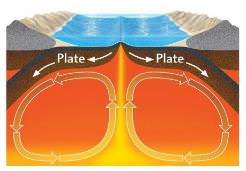
We have studied about convection currents in the mantle which are the primary reason behind plate movements ― divergence and convergence of the lithospheric plates.
The horizontal limbs of the convection currents, just below the lithosphere, drag the plates horizontally.
The falling limbs of the convection currents create a negative pressure on the lithosphere, and this negative pressure (pulling force) is responsible for the formation of the convergent boundary.
The rising limbs, on the other hand, create positive pressure on the lithosphere, and this positive pressure (pushing force) creates a divergent boundary.
Divergence (divergent boundary) is responsible for the evolution and creation of new seas and oceans just like convergent boundaries are responsible for the formation of fold mountains, volcanic arcs.
Evolution of a Divergent Boundary – Formation of Rift Valleys, Rift Lakes, Seas & Oceans
The formation of atmosphere and the oceans took millions of years. They were formed due to continuous ‘degassing’ of the Earth’s interior.
After the Earth’s surface temperature came down below the boiling point of water, rain began to fall.
Water began to accumulate in the hollows and basins, and the primeval (earliest) water bodies were formed.
The primeval water bodies evolved to form seas and oceans.
The process of formation of a new sea begins with the formation of a divergent boundary.
New lithosphere is created at the divergent boundary and old lithosphere is destroyed somewhere else at the convergent boundary.
Basic Terms:
Upwarp: a broad elevated area of the earth’s surface.
Plume: a column of magma rising by convection in the earth’s mantle.
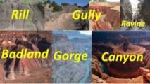
Rift Valley: a linear-shaped lowland (graben) between several highlands (horst) or mountain ranges created by the action of a geologic rift or fault.
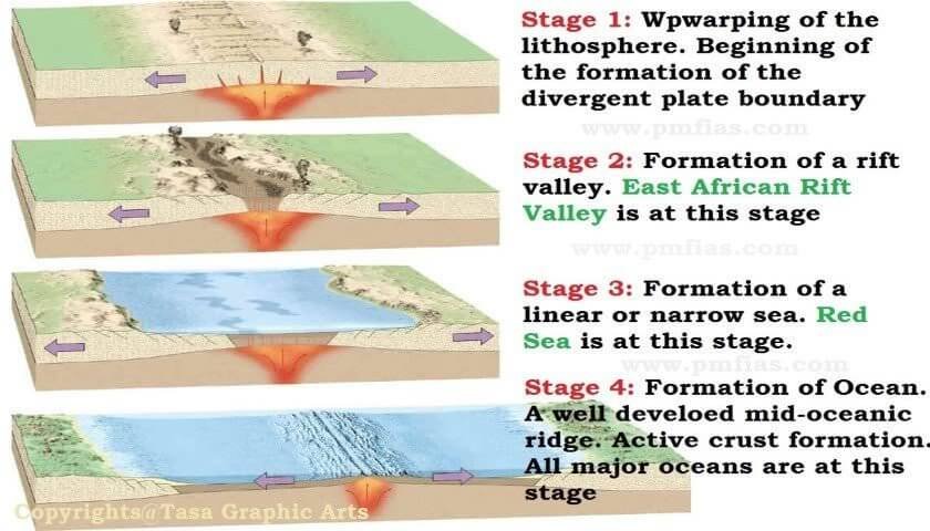
Stage 1: Upwarping, fault zones
Rising limbs of the convection currents create a plume that tries to escape to the surface by upwarping the lithosphere (doming the lithosphere upwards).
During upwarping, a series of faults are created. Both normal and thrust faults (reverse fault) occur during upwarping. The divergence of plates begin.
Stage 2: Rift Valley Formation
Faulting due to divergence creates extensive rift system (fault zones, rift valleys).
The lithosphere is subject to a horizontal extensional force, and it will stretch, becoming thinner (E.g. The crust above Yellowstone hotspot is thinning because of mantle plume).
Eventually, it will rupture, leading to the formation of a rift valley.
This process is accompanied by surface manifestations along the rift valley in the form of volcanism and seismic activity.
Rifts are the initial stage of a continental break-up and, if successful, can lead to the formation of a new ocean basin.
An example of a place on Earth where this has happened is the South Atlantic Ocean, which resulted from the breakup of South America and Africa around 138m years ago.
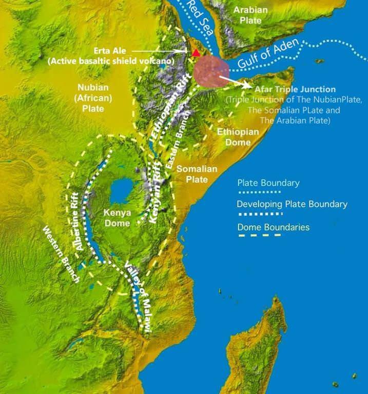
The East African Rift is described as an active type of rift. Beneath this rift, the rise of a large mantle plume is doming the lithosphere upwards (Ethiopian Highlands), causing it to weaken.
The rifting started in the Afar region in northern Ethiopia at around 30 million years ago and propagating southwards towards Zimbabwe. (It’s unzipping Africa!)
Rifting is followed by flood basalt volcanism in some places that spread around the rift creating plateaus and highlands (Ethiopian Highlands, Kenya Dome).
Mains 2018: What is a mantle plume and what role it plays in plate tectonics?
Backdrop: In early 2018, a large crack made a sudden appearance in south-western Kenya adding fuel to the debate on the breakup of Africa.
Narmada and Tapti Rift Valleys(fault zones) are formed from a mechanism different from the one explained above. They are formed due to the bending of the northern part of the Indian plate during the formation of Himalayas.
Stage 3: Formation of Linear Sea or Rift Lakes
Rift valley deepens due to further divergence and makes way for ocean waters.
If the rift valleys are formed deeper within the continents, rains waters accumulate forming rift lakes.
Rift lakes form some of the largest freshwater lakes on earth.
Rift valleys evolve into a volcanic vent. Block mountains on either side of the rift evolve into oceanic ridges.
Successive volcanism and seafloor spreading create spreading sites where new crust is formed (divergent boundary is also called a constructive edge).
Oceanic crust starts to replace continental crust. This stage is the formation of linear seas. Example: Red Sea.
Stage 4: Linear Sea transforms into Ocean
The intense outpouring of basaltic magma accentuates see floor spreading and oceanic crust formation.
Oceanic crust replaces the continental crust, and a mighty ocean is formed.
Crust formation along the mid-oceanic ridge (divergent boundary) is compensated by crust destruction (crustal shortening) along the convergent boundary (destructive Edge). This is how the continents and oceans get transformed.
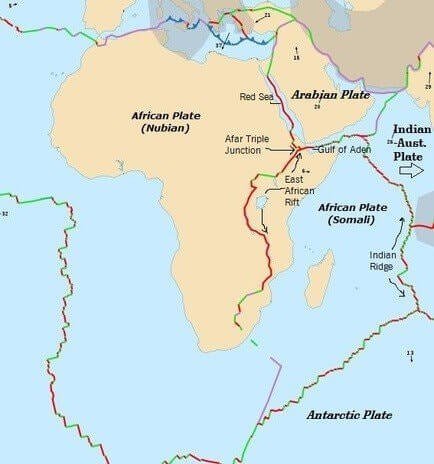
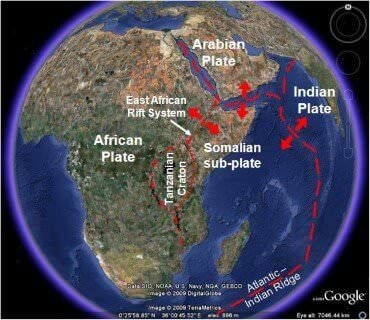
Great Rift Valley (The Best Example of a Divergent Boundary)
The Great Rift Valley is a geographical feature running north to south for around 6,400 kilometres from northern Syria to central Mozambique in East Africa.
The northernmost part of the Rift forms the Beqaa Valley in Lebanon.
Farther south, the valley is the home of the Jordan River which continues south through the Jordan Valley into the Dead Sea on the Israeli-Jordanian border.
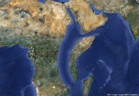
From the Dead Sea southward, the Rift is occupied by the Gulf of Aqaba and the Red Sea.
The Afar Triangle of Ethiopia and Eritrea is the location of a triple junction.
The Gulf of Aden is an eastward continuation of the rift, and from this point, the rift extends south-eastward as part of the mid-oceanic ridge of the Indian Ocean.
In a southwest direction, the fault continues as the Great Rift Valley, which split the older Ethiopian highlands into two halves.
In eastern Africa, the valley divides into the Eastern Rift and the Western Rift. The Western Rift, also called the Albertine Rift contains some of the deepest lakes in the world.
East African Rift Valley
The Eastern Rift Valley (also known as Gregory Rift) includes the main Ethiopian Rift, running eastward from the Afar Triple Junction, which continues south as the Kenyan Rift Valley.
The Western Rift Valley includes the Albertine Rift, and farther south, the valley of Lake Malawi.
To the north of the Afar Triple Junction, the rift follows one of two paths: west to the Red Sea Rift or east to the Aden Ridge in the Gulf of Aden.
The EAR transects through Ethiopia, Kenya, Uganda, Rwanda, Burundi, Zambia, Tanzania, Malawi and Mozambique.
Before rifting, enormous continental flood basalts erupted on the surface and uplift of the Ethiopian, Somalian, and East African plateaus occurred.
Breaking up of Africa
The East African Rift (EAR) is an active continental rift zone in East Africa.
The EAR began developing around the onset of the Miocene, 22-25 million years ago.
In the past, it was considered to be part of a larger Great Rift Valley.
The EAR is subjected to different stages of rifting along its length. To the south, where the rift is young, extension rates are low, and faulting occurs over a wide area. Volcanism and seismicity are limited.
Towards the Afar region, however, the entire rift valley floor is covered with volcanic rocks.
This suggests that, in this area, the lithosphere has thinned almost to the point of complete break-up.
The rift is a narrow zone that is a developing divergent tectonic plate boundary, in which the African Plate is in the process of splitting into two tectonic plates, called the Somali Plate and the Nubian Plate (African Plate), at a rate of 6–7 mm annually.
As extension continues, lithospheric rupture will occur within 10 million years, the Somalian plate will break off, and a new ocean basin will form.
Volcanism and seismicity along East African Rift Valley
The East African Rift Zone includes many active as well as dormant volcanoes.
Mount Kilimanjaro (it has three volcanic cones), is a dormant stratovolcano in Tanzania, Mount Kenya is an extinct stratovolcano.
Although most of these mountains lie outside of the rift valley, the EAR created them.
The EAR is the largest seismically active rift system on Earth today.
The majority of earthquakes occur near the Afar Depression, with the largest earthquakes typically occurring along or near major border faults.
How come Mount Kilimanjaro and Mount Kenya that formed close to the divergent boundary are stratovolcanoes when the magma that flows out at the divergent boundary is basaltic?
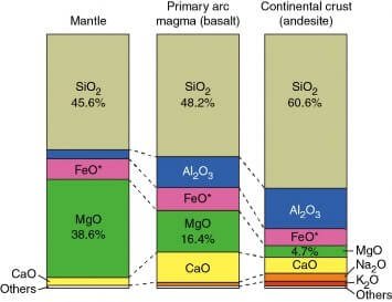
The formation of stratovolcano and shield volcano depends on the silica content of the magma.
Shield volcanoes are formed from magma that contains a low proportion of silicates (magma coming from the mantle, like in divergent boundary).
Stratovolcanoes are formed from magma that contains a high proportion of silicates (magma formed due to the melting of crustal plates, like in convergent boundary).
Mt Kilimanjaro is a stratovolcano. It was formed during the process of formation of the African rift valley.
During the formation of the African rift valley, there was a lot of faulting. The stress caused in the crustal plates led to the melting of the subsurface layer into magma, and the volcanism around Kilimanjaro occurred due to this magma (high proportion of silicates).
Take a look at the picture below to know the proportion of silicon content in mantle and crust.
Silicon content in the mantle, oceanic crust (mafic) and the continental crust (felsic)
Majority of the stratovolcanoes occur along the convergent boundary, but there is no fixed rule that they should occur only along convergent boundaries. It all depends on the nature of magma that flows out.