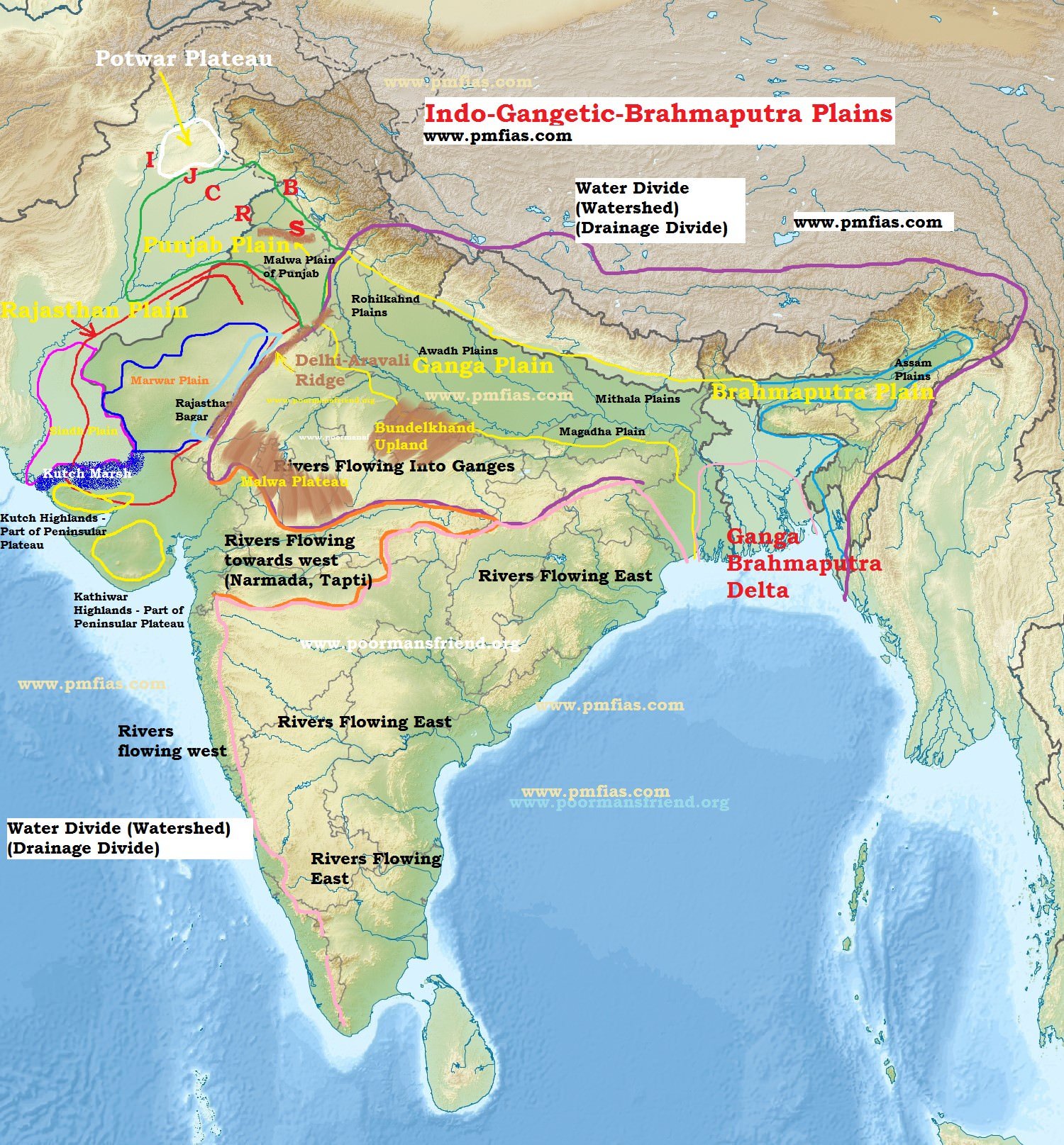
Regional Divisions of the Indo-Gangetic-Brahmaputra Plains [Great Plains]
Sindh Plain
Rajasthan Plain.
Punjab Plain.
Ganga Plain.
Brahmaputra Plain.
Ganga – Brahmaputra Delta
Sindh Plain [Pakistan]
Mainly formed of Bhangar Plains.
Dhors: Long narrow depressions which are the remnants of the course of former rivers.
Dhand: Alkaline lakes on some dhors.
Rajasthan Plain
Occupied by Thar or the Great Indian Desert.
This plain is an undulating plain [wave like] whose average elevation is about 325 m above mean sea level.
The desert region is called Marusthali and forms a greater part of the Marwar plain.
It has a few outcrops of gneisses, schists and granites which proves that geologically it is a part of the Peninsular Plateau. It is only at the surface that it looks like an aggradational plain.
In general, the eastern part of the Marusthali is rocky while its western part is covered by shifting sand dunes locally known as
The eastern part of the Thar Desert up to the Aravali Range is a semi-arid plain known as Rajasthan Bagar.
It is drained by a number of short seasonal streams originating from the Aravali and supports agriculture in some patches of fertile tracts.
Luni is an important seasonal stream which flows into Rann of Kuchchh. The tract north of the Luni is known as thali or sandy plain.
Saline Lakes
North of the Luni, there is inland drainage having several saline lakes. They are a source of common salt and many other salts.
Sambhar, Didwana, Degana, Kuchaman, etc. are some of the important lakes. The largest is the Sambhar lake near Jaipur.
Punjab Plain
This plain is formed by five important rivers of Indus system.
The plain is primarily made up of ‘doabs’ —the land between two rivers.
The depositional process by the rivers has united these doabs giving an homogenous appearance.
Punjab literally means “(The Land of) Five Waters” referring to the following rivers: the Jhelum, Chenab, Ravi, Sutlej, and Beas.
The total area of this plain is about 1.75 lakh sq km.
The average elevation of the plain is about 250 m above mean sea level.
The eastern boundary of Punjab Haryana plain is marked by subsurface Delhi-Aravali ridge.
The northern part of this plain [Shiwalik hills] has been intensively eroded by numerous streams called Chos. This has led to enormous gullying [Arid Landforms].
To the south of the Satluj river there is Malwa plain of Punjab.
The area between the Ghaggar and the Yamuna rivers lies in Haryana and often termed as ‘Haryana Tract’. It acts as water-divide between the Yamuna and the Satluj rivers.
The only river between the Yamuna and the Satluj is the Ghaggar which is considered to be the present day Successor of the legendary Saraswati River
Ganga Plain
This is the largest unit of the Great Plain of India stretching from Delhi to Kolkata (about 3.75 lakh sq km).
The Ganga along with its large number of tributaries originating in the Himalayans have brought large quantities of alluvium from the mountains and deposited it here to build this extensive plain.
The peninsular rivers such as Chambal, Betwa, Ken, Son, etc. joining the Ganga river system have also contributed to the formation of this plain.
The general slope of the entire plain is to the east and south east.
Rivers flow sluggishly in the lower sections of Ganges as a result of which the area is marked by local prominences such as levees, bluffs, oxbow lakes, marshes, ravines, etc. {Fluvial Landforms, Arid Landfroms}
Almost all the rivers keep on shifting their courses making this area prone to frequent floods. The Kosi river is very notorious in this respect. It has long been called the ‘Sorrow of Bihar’.
Regional divisions of Ganga plains
Rohilkhand plains
Avadh Plains
Mithila Plain
Magadh Plain.
Ganga-Brahmaputra Delta
This is the largest delta in the world.
The Ganga river divides itself into several channels in the delta area. The slope of the land here is a mere 2 cm per km. Two thirds of the area is below 30 m above mean sea level. [Highly vulnerable to sea level changes]
The seaward face of the delta is studded with a large number of estuaries, mud flats, mangrove swamps, sandbanks, islands and forelands.
Large part of the coastal delta is covered tidal forests. These are called the Sunderbans because of the predominance of Sundri tree here.
Brahmaputra Plain
This is also known as the Brahmaputra valley or Assam Valley or Assam Plain as most of the Brahmaputra valley is situated in Assam.
Its western boundary is formed by the Indo-Bangladesh border as well as the boundary of the lower Ganga Plain. Its eastern boundary is formed by Purvanchal hills.
It is an aggradational plain built up by the depositional work of the Brahmaputra and its tributaries.
The innumerable tributaries of the Brahmaputra river coming from the north form a number of alluvial fans. Consequently, the tributaries branch out in many channels giving birth to river meandering leading to formation of bill and ox-bow lakes.
There are large marshy tracts in this area. The alluvial fans formed by the coarse alluvial debris have led to the formation of terai or semi-terai conditions.
Significance of the Plain
This one fourth of the land of the country hosts half of the Indian population.
The extensive use of irrigation has made Punjab, Haryana and western part of Uttar Pradesh the granary of India (Prairies are called the granaries of the world).
The entire plain except the Thar Desert, has a close network of roads and railways which has led to large scale industrialization and urbanization.
Cultural tourism: There are many religious places along the banks of the sacred rivers like the Ganga and the Yamuna which are very dear to Hindus. Here flourished the religions of Budha and Mahavira and the movements of Bhakti and Sufism.