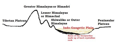
Formation of Indo – Gangetic – Brahmaputra Plain
- The formation of Indo-Gangetic plain is closely related to the formation of Himalayas.
- The rivers which were previously flowing into Tethys sea (Before Indian Plate collided with Eurasian Plate – continental drift, plate tectonics) deposited huge amount of sediments in the Tethys Geosyncline. [Geosyncline – a huge depression]
- Himalayas are formed out of these sediments which were uplifted, folded and compressed due to northern movement of Indian Plate.
- Northern movement of Indian Plate also created a trough to the south of Himalayas.
Depositional Activity
- During the initial stages of upliftment of sediments, the already existing rivers changed their course several times and they were rejuvenated each time (perpetual youth stage of rivers {Fluvial Landforms}).
- The rejuvenation is associated with intense headward and vertical downcutting of the soft strata overlying the harder rock stratum.
- Headward erosion and vertical erosion of the river valley in the initial stages, lateral erosion in later stages contributed huge amount of conglomerates (detritus)(rock debris, silt, clay etc.) which were carried downslope.
- [Head ward erosion == Erosion at the origin of a stream channel, which causes the origin to move back away from the direction of the stream flow, and so causes the stream channel to lengthen]
- These conglomerates were deposited in the depression (Indo-Gangetic Trough or Indo-Gangetic syncline) (the base of the geosyncline is a hard crystalline rock) between peninsular India and the convergent boundary (the region of present day Himalayas).
New rivers and more alluvium
- The raising of Himalayas and subsequent formation of glaciers gave rise to many new rivers. These rivers along with glacial erosion {Glacial Landforms}, supplied more alluvium which intensified the filling of the depression.
- With the accumulation of more and more sediments (conglomerates), the Tethys sea started receding.
- With passage of the time, the depression was completely filled with alluvium, gravel, rock debris (conglomerates) and the Tethys completely disappeared leaving behind a monotonous aggradational plain.
- [monotonous == featureless topography; aggradational plain == plain formed due to depositional activity. Indo-Gangetic plain is a monotonous aggradational plain formed due to fluvial depositions].
- Upper peninsular rivers have also contributed to the formation of plains, but to a very small extent.
- During the recent times (since few million years), depositional work of three major river systems viz., the Indus, the Ganga and the Brahmaputra have become predominant.
- Hence this arcuate (curved) plain is also known as Indo-Gangetic-Brahmaputra Plain.
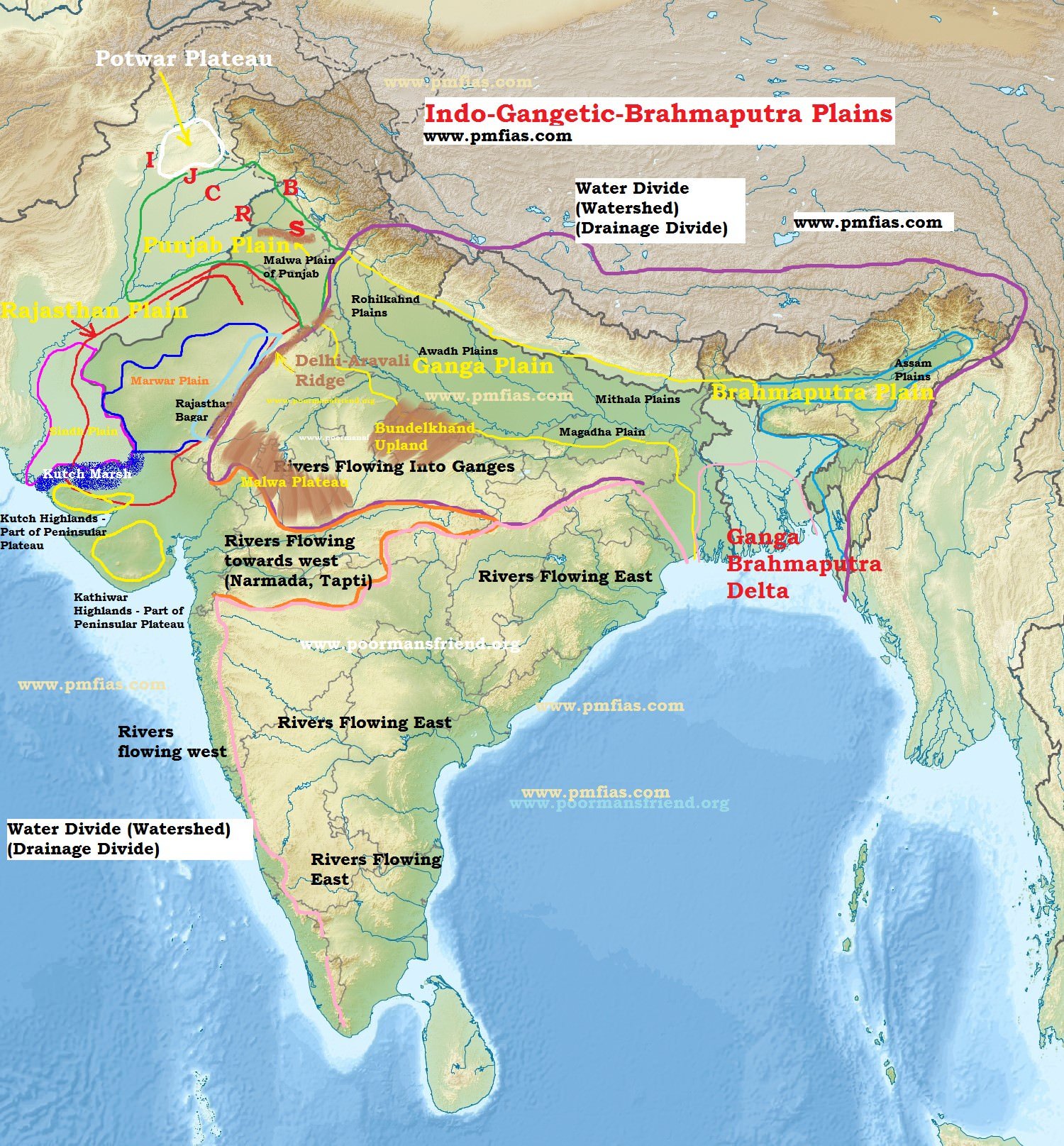
Features of Indo – Gangetic – Brahmaputra Plain
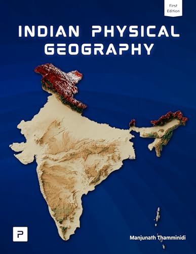
- Indo-Gangetic-Brahmaputra Plain is the largest alluvial tract of the world.
- It stretches for about 3,200 km from the mouth of the Indus to the mouth of the Ganga. Indian sector of the plain accounts for 2,400 km.
- The northern boundary is well marked by the Shiwaliks and the southern boundary is a wavy irregular line along the northern edge of the Peninsular India.
- The western boarder is marked by Sulaiman and Kirthar ranges. On the eastern side, the plains are bordered by Purvanchal hills.
- The width of the plain varies from region to region. It is widest in the west where it stretches for about 500 km. Its width decreases in the east.
- The thickness of the alluvium deposits also vary from place to place. The maximum depth of the alluvium up to the basement rocks is about 6,100 m (not uniform and varies greatly from place to place).
- The cones or alluvial fans of Kosi in the north and those of Son in the south exhibit greater alluvial thickness while the intra-cone areas have relatively shallower deposits.
- Extreme horizontality of this monotonous plain is its chief characteristic.
- Its average elevation is about 200 m above mean sea level, highest elevation being 291 m above mean sea level near Ambala (This elevation forms the drainage divide or watershed between Indus system and Ganga system).
- Its average gradient from Saharanpur to Kolkata is only 20 cm per km and it decreases to 15 cm per km from Varanasi to the Ganga delta.
Geomorphological features of Indo – Gangetic – Brahmaputra Plain
The Bhabar
- It is a narrow, porous, northern most stretch of Indo-Gangetic plain.
- It is about 8-16 km wide running in east-west direction along the foothills (alluvial fans) of the Shiwaliks.
- They show a remarkable continuity from the Indus to the Tista.
- Rivers descending from the Himalayas deposit their load along the foothills in the form of alluvial fans.
- These alluvial fans have merged together to build up the bhabar belt.
- The porosity of bhabar is the most unique feature.
- The porosity is due to deposition of huge number of pebbles and rock debris across the alluvial fans.
- The streams disappear once they reach the bhabar region because of this porosity.
- Therefore, the area is marked by dry river courses except in the rainy season.
- The Bhabar belt is comparatively narrow in the east and extensive in the western and north-western hilly region.
The area is not suitable for agriculture and only big trees with large roots thrive in this belt.
The Terai
- Terai is an ill-drained, damp (marshy) and thickly forested narrow tract to the south of Bhabar running parallel to it.
- The Terai is about15-30 km wide.
- The underground streams of the Bhabar belt re-emerge in this belt.
This thickly forested region provides shelter to a variety of wild life. [Jim Corbett National Park in Uttarakhand and Kaziranga National Park in Assam lie in terai region]

- The Terai is more marked in the eastern part than in the west because the eastern parts receive comparatively higher amount of rainfall.
- Most of the Terai land, especially in Punjab, Uttar Pradesh and Uttarakhand, has been turned into agricultural land which gives good crops of sugarcane, rice and wheat.
The Bhangar
- The Bhangar is the older alluvium along the river beds forming terraces higher than the flood plain.
- The terraces are often impregnated with calcareous concretions known as ‘KANKAR’.
- ‘The Barind plains’ in the deltaic region of Bengal and the ‘bhur formations’ in the middle Ganga and Yamuna doab are regional variations of Bhangar.
[Bhur denotes an elevated piece of land situated along the banks of the Ganga river especially in the upper Ganga-Yamuna Doab. This has been formed due to accumulation of wind-blown sands during the hot dry months of the year]
- Bhangar contains fossils of animals like rhinoceros, hippopotamus, elephants, etc.
The Khadar
- The Khadar is composed of newer alluvium and forms the flood plains along the river banks.
- A new layer of alluvium is deposited by river flood almost every year.
- This makes them the most fertile soils of Ganges.
Reh or Kollar
- Reh or Kollar comprises saline efflorescences of drier areas in Haryana.
- Reh areas have spread in recent times with increase in irrigation (capillary action brings salts to the surface).
Primary References: NCERT Geography, Indian Geography by Kullar [Amazon and Flipkart]
Newsletter Updates
Subscribe to our newsletter and never miss an important update!
Assured Discounts on our New Products!


Thank you so much, great content – very helpful 🙂
Thank you so much for your invaluable notes. It is very helpful as all the pictures and info are given in such a concise manner.Kudos!!
Rectify the Indian map given above, by providing map that includes kashmir and ladakh region properly..
Be a proud Indian✌