PMF IAS Current Affairs

Current Affairs for UPSC Civil Services Exam – April 18, 2024

{GS1 – Geo – PG – Climatology} Extreme Weather Event in Dubai & Mumbai

  • Context (DTE| HT | DTE | TH | IE): Mumbai and Dubai, two big cities, faced extreme weather on April 16, 2024.
  • Dubai had heavy rain and lightning, causing floods in many areas. Mumbai experienced intense heat and humidity.

Scenario in Mumbai

  • Mumbai’s Konkan coast has been in a hot, humid heatwave for two days.
  • On April 16, the Santa Cruz station recorded its highest temperature in 15 years, reaching 39°C.

Scenario in Dubai

  • Dubai experienced over a year and a half’s worth of rainfall in just one day on April 16.
  • The heavy rain flooded the city’s airport and major roads, causing widespread damage.
  • Other cities in the United Arab Emirates (UAE), like Sharjah and Abu Dhabi, also faced excessive rainfall.
  • Oman, Saudi Arabia, and Bahrain also experienced heavy rainfall, resulting in flash floods.

The cause

  • Both the extreme rainfall in Dubai and the intense heat in Mumbai were linked to a large anticyclonic system that covered a vast area from West Asia to the Himalayan foothills.

The explanation for Mumbai’s hot weather

  • Anticyclones are areas of high atmospheric pressure.
  • Winds in anticyclones move downward and compress, causing heating. They often lead to large-scale heatwaves.
  • Anticyclones can block other weather systems, causing extreme conditions around them.
  • In Mumbai, the anticyclone caused a “heat domeeffect, warming the air further.
  • Warm air from West Asia and the Arabian Sea was drawn in and heated by sinking motion. This increased humidity in Mumbai, especially before the monsoon season.
  • Normally, sea breezes cool Mumbai at night, but the anticyclone may have blocked them. As a result, night temperatures were higher than usual.

The explanation for the Dubai floods

  • The anticyclone stopped a weather system called a western disturbance from moving over West Asia.
  • This interaction with the anticyclone may have contributed to the storm system that caused the rainfall and lightning. Experts explain that the western disturbance interacted with the anticyclone’s western edge. Thus, extreme weather in Dubai could be partly related to the presence of the large anticyclone.
Other possible reasons for Dubai floods
  • Media reports suggest that the UAE National Centre of Meteorology’s cloud seeding operations might have intensified the rainfall from the storm system.
  • Excessive dust in the region could also act as natural cloud seeders, contributing to the heavy rainfall.
    • Dust acts as condensation nuclei, contributing to cloud formation, similar to man-made cloud seeding.
  • Record heat in 2023 and 2024, along with warming in West Asia and the Arabian Sea, created unusual heat conditions.
    • The National Center of Meteorology’s (NCM) Annual Climate Assessment 2022 noted that the UAE’s climate had warmed by 0.4°C from the long-term average (2003-2022).
  • According to some experts, rainfall is becoming much heavier around the world as the climate warms because a warmer atmosphere can hold more moisture.
    • Global warming has led to exceptionally warm water in the seas near Dubai, accompanied by warm air above.
    • This combination enhances the potential for evaporation and increases the atmosphere’s capacity to hold moisture.
    • As a result, we see larger amounts of rainfall, as evidenced by the recent heavy downpours in Dubai
  • According to a senior forecaster at the UAE’s National Centre of Meteorology, a low-pressure system in the upper atmosphere, combined with low pressure at the surface, squeezed the air.
    • This pressure squeeze was intensified by the difference in temperature between the warmer ground level and the colder higher altitude. These conditions created the perfect setup for the powerful thunderstorm.
  • Other factors, like the transition from El Nino to La Nina, could have influenced the weather.

Cyclone vs Anticyclone

Anticyclones - Geography Notes

Cyclone Anticyclone
  1. It represents areas of low pressure.
It represents areas of high pressure.
  1. Cyclones spin in a counterclockwise direction in the Northern Hemisphere and clockwise in the Southern Hemisphere.
Anticyclones spin in a clockwise direction in the Northern Hemisphere and counterclockwise in the Southern Hemisphere.
  1. Cyclones are associated with clouds, rain and thunderstorms.
Anticyclones are associated with fair weather but can lead to temperature extremes and poor air quality under certain conditions.
  1. Air moves upward, creating Convergence
Air moves downward, creating divergence
  • The shift in the upper-level jet stream brings western disturbances to India, causing rainfall and snowfall in winter and spring.

Heat Dome

  • A heat dome occurs when the atmosphere traps hot ocean air like a lid or cap.

Heat Dome and Omega Block Description automatically generated

Cloud Seeding

  • Clouds are made up of tiny water droplets or ice crystals that form when water vapour in the atmosphere cools and condenses around a tiny particle of dust or salt floating in the atmosphere.
  • Without these particles, known as condensation or ice nuclei, raindrops or snowflakes cannot form, and precipitation will not occur.
  • Cloud seeding is a weather modification technique that improves a cloud’s ability to produce rain or snow by introducing tiny ice nuclei into certain types of subfreezing clouds. These nuclei provide a base for water raindrops to form.
  • During cloud seeding, chemicals like silver iodide are used to create ice crystals that attract water vapour and form rain clouds.
  • The UAE has used cloud seeding in the past to increase rainfall in desert areas, although it has been controversial in other places.

Scientists are waiting for appropriate cloud conditions in Delhi to create  artificial rain through cloud-seeding in the Capital.

{GS2 – Vulnerable Sections – Women} Gate Cane Weddings in Marathwada

  • Context (DTE): Sugarcane industry & cyclic droughts aggravate early-age marriages in Marathwada.
  • The Marathwada region of Maharashtra is historically prone to drought due to recurring dry spells and water-intensive sugarcane cultivation.
  • The resulting loss of livelihoods often results in the mass migration of locals as sugarcane cutters in the various parts of the state.

Gate cane weddings

  • These are shortcut weddings that are fixed and solemnised within hours or a couple of days, followed by peak drought months.
  • The practice evolved after the 1972 drought, which was one of the worst in the region.
  • Minimum arrangements: No printed invitation, wedding tent, or wedding procession or band, minimal guests, and usually homecooked food.
  • It is more popular across villages, with a high number of migrant labourers as sugarcane cutters.

Reasons behind such quick-fix weddings

  • It evolved from the hiring practices followed in the labour-intensive sugarcane industry.
  • Post-1972 drought, women entered the sugarcane industry as labourers to support the males.
  • Contractors who recruit labourers usually prefer a married couple known as “koyta” or a sickle.
  • An adolescent girl-turned-wife helps with unpaid domestic chores and as a labourer or worker supporting her husband.
  • Contractors lure the couple by offering them advances as loans for the upcoming harvest season.
  • If the debt remains unpaid due to lack of harvest or poor yield, the family is then forced to enter the vicious cycle.
  • Other factors include caste, number of daughters, dowry, debt, access to groundwater, land ownership, and the relationship between wife-takers and givers.

Data

  • As per the National Family Health Survey (2019-21), about 43 per cent of the women across the region recorded underage marriages.
  • Marathwada’s rate of underage marriage is almost two-fold that of the state, with 22 per cent.
  • As per a study, during the 2010s, when the region witnessed a series of droughts, early marriages increased by 20 per cent.

{GS3 – Envi – CC} Heatwave | Heat Action Plan

  • Context (TH): Parts of Odisha, West Bengal, Telangana, Andhra Pradesh and others are expected to face heatwave conditions.

No alt text provided for this image

  • A heat wave is defined based on the temperature thresholds over a region in terms of actual temperature or its departure from normal.
  • In certain countries, it is defined in terms of the heat index based on temperature and humidity or based on the extreme percentile of the temperatures.

Criterion for Declaring Heat Wave

  • Heatwave is considered if the maximum temperature of a station reaches at least 40˚C or more for Plains and at least 30˚C or more for Hilly regions.

Based on Departure from Normal

  • Heat Wave: Departure from normal is 4.5˚C to 6.4˚C.
  • Severe Heat Wave: Departure from normal is >6.4˚C.

Based on Actual Maximum Temperature

  • Heat Wave: When actual maximum temperature ≥ 45˚C.
  • Severe Heat Wave: When actual maximum temperature ≥47˚C.
  • If the above criteria are met at least in 2 stations in a Meteorological sub division for at least two consecutive days, it is declared on the second day.

Criteria for Heat Wave for Coastal Conditions

  • When maximum temperature departure is 4.5˚C or more from normal, a Heat Wave may be described, provided the actual maximum temperature is 37˚C or more.

IMD Colour-Coded Warnings

Prelim Bits 21-07-2023 | UPSC Daily Current Affairs | Prelim Bits | Current  Affairs

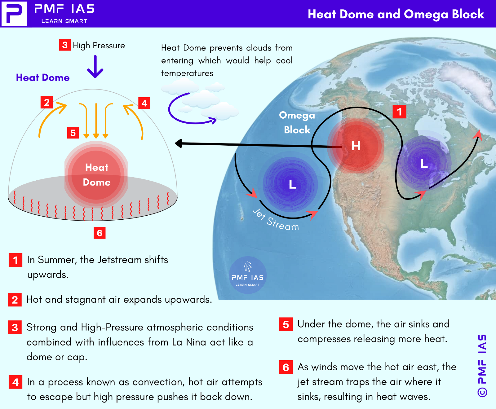
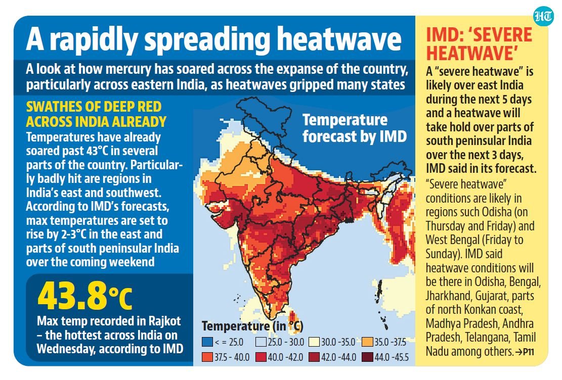
Learn more on Heat Waves, Indian Meteorological Department.

Heat Action Plan

  • HAPs are India’s primary policy response to economically damaging and life-threatening heatwaves.
  • They prescribe a variety of preparatory activities, disaster responses, and post-heatwave response measures across state, district, and city government departments to increase preparedness and lower the adverse impacts of extreme heatwaves.
  • Odisha first developed a Heat Action Plan in 1999 following more than 2,000 Heat Wave deaths in 1998.
  • Followed by this, the first city level Action Plan was developed by Ahmedabad in 2013 following severe Heat Wave in 2010.
  • The National Disaster Management Authority and IMD are reported to be working with 23 States to develop HAPs.
  • There is no centralised database on HAPs, but at least 23 HAPs exist at the State and city level, with a few States, such as Odisha and Maharashtra, laying out district-level HAPs.

What do HAPs recommend?

  1. Establish Early Warning System and Inter-Agency Coordination
    • Early Warning and Indicators of heat-wave
    • Forecast and Issuance of Heat Alert or Heat Warning
    • Identification of Color Signals for Heat Alert
  2. Capacity building/training programme for health care professionals at local level to recognize and respond to heat-related illnesses, particularly during extreme heat events.
  3. Public Awareness and community outreach on how to protect against the extreme heat-wave through print, electronic and social media and Information.
  4. Collaboration with non-government and civil society to improve bus stands, build temporary shelters, improve water delivery systems in public areas, etc to tackle Heat wave conditions.

What debilitates HAPs from addressing the problem effectively?

Ignoring the local context
  • The HAPs (except Odisha and Rajkot HAPs) lack climate analysis of the city or state where it will be implemented.
  • A national threshold is what determines a heatwave today. Many cities have been reeling under extreme temperatures, although no heatwave has been declared.
Failure to include assessment of Socio-economic differences in Heat Stress Prone Areas
  • The lack or presence of cooling solutions, the ability to afford them, the ratio of size to inhabitants, and the community infrastructure all play a key role in understanding the residents’ ability to respond to heat waves.
  • It also can help inform priority areas for implementing adaptation and mitigation infrastructure.
Not Climate-Vulnerability Based
  • Ignoring historical climate trends and ground-level assessments of hotspots and socio-economic status has made the HAPs static in nature.
  • Thus, the HAP framework is not equipped to develop pre-emptive strategies for key vulnerable areas and those most at risk from heat waves.
Understanding Climate Change Projection
  • Very few Action Plan Strategies (like the Telangana Heat Action Plan) have given due consideration to climate change projections and the cumulative impact of the growing urban population.
  • The impact of urbanisation and climate change on Heat Waves needs to be studied in detail and considered while framing Action Plans.
Inconsistent methods
  • While most HAPs have conducted vulnerability assessments during the development of the plans, the methods adopted are inconsistent.
  • It is time to transition to a robust, full-fledged climate risk assessment that can identify the likelihood of heat waves in different areas and estimate the exposure of people and important assets to heat waves.
  • Hotspot mapping is needed to prioritise and formulate targeted interventions, which is now possible with easy-to-access geospatial data.
Vulnerable populations
  • All HAPs prioritise the protection of vulnerable populations such as low-income communities, children, and the elderly.
  • However, what is missing are targeted interventions that account for the varying needs of populations based on local social and demographic factors, in addition to infrastructure elements that could exacerbate heat.

Way Forward

Factoring in Regional Variations
  • The scope of a heatwave needs to be expanded to accommodate humid heat, warmer nights, and extreme dry heat. This requires the development of a heat index that accounts for multiple factors beyond temperature.
  • Regional variations also need to be considered, as HAPs that are tailored to specific climatic conditions, demography, and a region’s infrastructure can lead to the formulation of strategies and interventions suited to the local context.
Understanding Heat Hotspots
  • External factors that influence the heat profile of the areas should also be included.
  • Factors like urban heat Islands and how they interact with the existing heat hotspots must be studied and included to help authorities understand the actual changes in temperatures during, before, and after the heatwave occurrences. However, most HAPs lack this analysis.
Resource allocation
  • The implementation of HAPs can vary significantly depending on the priorities of local governments and the capacities available. Allocating dedicated budgets for HAPs is necessary.
  • Further, dialogues between the state, civil society organisations, and worker unions are essential to co-plan a financial mechanism that allows informal workers to stay indoors during a heatwave without losing their income.
Breaking down silos
  • HAPs currently are stand-alone plans with limited finance.
  • Pooling in resources would be possible if they are integrated with broader action plans promoting urban resilience and climate adaptation.
  • Such integration will likely affect the overall effectiveness of HAPs and their implementation, prompting improvements in data collection and monitoring systems, which are essential to helping assess their effectiveness over time.
Focus on building infrastructure
  • Finally, while HAPs mention long-term measures, they are limited to building infrastructure (especially cool roofs), with a cursory mention of green and blue spaces.
  • For HAPs to be effective, focused planning on including nature-based solutions to address extreme heat in hotspots is a must.

{GS3 – Envi – Conservation} Change in GCP Rule 2023

Qualification for reforested landscape

  • Earlier requirement: Minimum of 1,100 trees per hectare in restored forest.
  • Revised guideline: The Ministry has now left it to states.
  • Reason: The Ministry argues that not all degraded forests can support that kind of density. Thus, shrubs, herbs, and grasses may be suitable for restoring the ecosystem in some places.

Green credit quantification

  • Earlier: Companies could offset all compensatory afforestation obligations using green credits.
  • Revised: They could only claim a portion of it. Moreover, the quantification of grasses and shrubs as green credit still needs to be worked out.
  • Moreover, preference would be given to indigenous species.

{GS3 – IE – Growth} UNCTAD Report

  • Context (TH): In its recent report, UN Trade and Development (UNCTAD) stated that India achieved a growth rate of 6.7% in 2023 and is projected to maintain strong expansion with a growth rate of 6.5% in 2024. This positions India as the fastest-growing major economy globally.
  • The UNCTAD report contrasts with the International Monetary Fund’s (IMF) World Economic Outlook (published 2 times a year).
  • The IMF predicts strong growth in India, with 6.8% in 2024 and 6.5% in 2025, driven by robust domestic demand and a growing working-age population.

Factors that will support high growth in India for 2024

  • Strong public investments
  • Thriving services sector.
  • Robust local demand for consumer services
  • High external demand for Indian business services exports supported this growth.
  • Multinational companies expanding their manufacturing operations into India will boost Indian exports. (China Plus One strategy).
  • Strong investment in South Asia, particularly in India.(According to another UN report called ‘2024 Financing for Sustainable Development Report‘)

Other Findings

  • In other Southern Asian countries like Bangladesh, Pakistan, and Sri Lanka, economic growth is slower.
    • These countries are under IMF programs, which require tight monetary policies and fiscal austerity measures. These measures most affect low-income households.
  • Global economic growth is forecasted to be 2.6% in 2024, slightly lower than 2.7% in 2023.
    • This marks the third consecutive year of slower growth compared to the pre-pandemic average of 3.2% from 2015 to 2019.
    • Some economies, including China, India, Indonesia, the Russian Federation, and the United States, managed to avoid financial trouble.
    • As a result, the world economy grew by 2.7%, just above the 2.5% threshold often linked with a global recession. However, this positive trend is now at risk.
    • Threats: Challenges like trade disruptions, climate change, low growth, under-investment, and inequalities are becoming more serious.
  • China’s economy is projected to grow by 4.9% in 2024 but faces challenges like external uncertainties, a troubled housing market, and subdued consumption.
  • The UNCTAD report expects the RBI to maintain interest rates for the near future.

{GS3 – S&T – Defence} SPACE

  • Context (PIB): Submersible Platform for Acoustic Characterisation and Evaluation (SPACE) was inaugurated.

Submersible Platform for Acoustic Characterisation and Evaluation (SPACE)

  • The Naval Physical & Oceanographic Laboratory (NPOL) of DRDO set it up.
  • It will have a floater and a submersible platform.
  • Two parts: The floater will float on the water’s surface while the platform can be lowered up to 100m to carry out the operation.

Applications

  • To evaluate the complete sonar system.
  • Survey, sampling, and data collection of air, surface, mid-water, and reservoir floor parameters using modern scientific instrumentation.
  • This will lead to improved anti-submarine warfare research capabilities.

SONAR

  • Full form: Sound Navigation and Ranging.
  • It is a scientific instrument for exploring and mapping the ocean because sound waves travel farther in the water than radar and light waves.

{GS3 – S&T – Space} Black hole Gaia BH3

  • Context (DTE): Astronomers have detected the largest stellar black hole, Gaia BH3. It was detected using the data from the Gaia Mission.

A screenshot of a space program
Description automatically generated

  • European Space Agency launched the Gaia mission in 2013 with the goal of building the largest, most precise three-dimensional map of our galaxy by surveying nearly two billion objects.
  • Generally, stellar black holes were found because they exist as binaries (pairs) with a companion star.
  • Gaia BH3 was observed, causing an odd ‘wobbling’ motion on the companion star orbiting it.
  • Its mass is 33 times the Sun, and it is the second closest black hole to Earth (2000 light years away).
  • Cygnus X-1 was the most massive stellar black hole earlier (21 times the Sun) in the Milky Way.
  • When a star with more than eight times the Sun’s mass runs out of fuel, it explodes as a supernova, and its core collapses to form a stellar black hole.

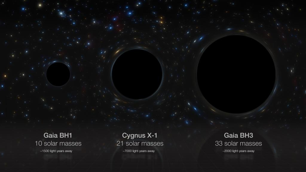
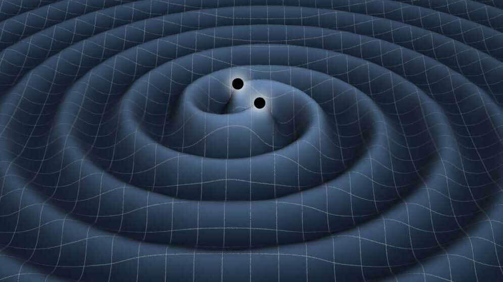
To know more, visit > Black Holes.

{Prelims – Envi – Species} Leptanilla Voldemort

  • Context (TOI | HT): A new ant species, Leptanilla Voldemort, named after a Harry Potter villain, has been discovered In the remote and rugged landscapes of Western Australia’s Pilbara region.
  • It belongs to a genus of ants known for their subterranean lifestyle and pale, almost translucent bodies.
  • It is slender and pale with long mandibles that hint at a predatory nature.
  • The discovery sheds light on understudied subterranean ecosystems and underscores the importance of continued exploration.

Scientists say this newly discovered ant species “live exclusively underground and are fearsome predators”. (X/@MarkKLWong, screengrab)

{Prelims – Sci – Bio – Diseases} Monkey Virus

  • Context (DTE): A 37-year-old man wounded by a wild monkey in Hong Kong is suffering from infection with B virus.
  • Although this is the first reported case of a B virus infection in a human in Hong Kong, it is not the first in the world.
  • Monkey B virus, initially isolated in 1932, is an alphaherpesvirus enzootic in macaques of the genus Macaca.
  • It is a biosafety category 4 virus, the highest level — the same as Ebola and unknown new pathogens.
  • It is the only identified old-world-monkey herpesvirus that displays severe pathogenicity in humans.
  • Host: Macaque monkeys, including rhesus macaques and pig-tailed macaques, are the most common host for the herpes B virus.
  • Symptoms: Flu-like symptoms such as fever and chills, muscle ache, fatigue and headache, small blisters in the area that came in contact with the monkey, shortness of breath, nausea, vomiting, abdominal pain, damage to brain & nervous system and in extreme cases, death.
  • Transmission: Via direct contact and exchange of bodily secretions of monkeys and has a fatality rate of 70 per cent to 80 per cent.
  • Treatment: Prompt treatment with antiviral drugs can be lifesaving, but B virus remains a deadly pathogen. If not treated promptly, it has a mortality rate of 70%. There is no vaccine against this virus.
Sharing is Caring !!

Newsletter Updates

Subscribe to our newsletter and never miss an important update!

Assured Discounts on our New Products!

Leave a Reply

Your email address will not be published. Required fields are marked *

Newsletter

Never miss an important update!